Social Studies
Reading Maps
Reading maps
Title, key, scale, compass directions and grid references, then the map of Ghana and your own district.
What is a map?
A map is a drawing of a place seen from above, made smaller so it fits on a page or a screen. It shows where things are and how far apart they are.
Imagine a bird flying over your school. It sees the roofs of the classrooms, the football field, the path to the gate, the road outside. If the bird could draw what it saw, that drawing would be a map.
Maps are old. People scratched them on clay and drew them on animal skin thousands of years ago. Today they are also on phones, in trotros, on the walls of the district assembly and in your social studies textbook.
Maps answer questions:
- Where is Tamale compared to Accra?
- Which road goes from Kumasi to Sunyani?
- How far is the clinic from the school?
- Which regions share a border with the Volta Region?
To answer these questions, a map uses a set of tools: a title, a key, a scale, a compass and often a grid. This book teaches you each one, and then you will use them on the map of Ghana and your own district.
2 / 44
The parts of a map
Almost every good map has the same five parts. Learn to find them first, before you look at anything else.

1. Title. Tells you what the map shows. On the map above the title is simply "Ghana".
2. Key (or legend). Explains the colours, lines and symbols. A yellow line might mean a main road; a blue square might mean a national park.
3. Scale. Tells you how much smaller the map is than real life, so you can measure distances. On this map, a short bar shows how long 50 km is.
4. Compass. Shows which way is north. On this map it is the arrow at the bottom right.
5. Grid (not on every map). Lines that divide the map into squares so you can describe exactly where something is.
Together these are sometimes remembered as TKSCG, or you can make your own memory sentence.
3 / 44
Kinds of maps
Not all maps show the same things. Before you read one, work out which kind it is. The title usually tells you.
Political maps show boundaries: countries, regions, districts, and their capitals. The regions map of Ghana is political. Colours separate one region from another and have no other meaning.
Physical (relief) maps show the land itself: mountains, plateaus, lowlands, rivers and lakes. Colours mean height.
Road maps show roads of different sizes, towns and distances. Drivers use them. The thick lines are the trunk roads; the thin ones are feeder roads.
Street maps show one town at a large scale: every street, with names, plus landmarks like markets, churches, mosques and lorry parks.
Thematic maps show one topic laid over the outline of a place: rainfall, population, crops, languages, diseases, election results. The key explains the shading.
Sketch maps are quick hand-drawn maps, like the one you draw for a friend to find your house. Not to scale, but still useful.
Try this For each question, say which kind of map you would need: Where does cocoa grow? Which road goes to Ho? Where is the Tamale lorry park? Which regions border Ashanti?
4 / 44
Maps through history
People have made maps for thousands of years. The oldest known maps were scratched on clay tablets in Babylon over 2 500 years ago. Ancient Egyptians drew maps of the Nile on papyrus.
For most of history, map-makers (called cartographers) worked from travellers' stories and their own measurements. Coastlines were drawn fairly well because sailors knew them. Inland areas were often guessed or left blank.
Maps of Ghana. European traders drew the Gold Coast from the 1400s onwards, marking the forts at Elmina, Cape Coast and Accra. These maps were made for trade and often ignored the towns and kingdoms inland. In the 1900s the colonial Survey Department made the first detailed maps of the whole country, measuring it piece by piece on foot. After independence, the Survey and Mapping Division of the Lands Commission took over, and Ghana produced its own national map series.
Today. Satellites photograph the whole Earth every few days. GPS satellites let a phone fix its position to within a few metres. Volunteers add roads and buildings to free online maps. Yet the rules of reading a map, its title, key, scale, compass and grid, are the same as they were on clay.
Try this Ask the oldest person in your family what maps they remember using at school. How were they different from today's?
5 / 44
The title
The title is the first thing to read. It tells you what the map is about and saves you from guessing.
Compare these titles:
- Ghana: Regions
- Ghana: Rainfall
- Ghana: Main Roads
- Accra Metropolitan Area: Schools
All four maps might show the same outline of the country or city. But they tell completely different stories. On the rainfall map, the colours mean millimetres of rain. On the regions map, the colours mean regions. If you did not read the title, you might think the Western Region had more rain than the Upper East simply because it was a darker colour.
A good title also tells you when. A map titled Regions of Ghana (2018) shows ten regions. A map titled Regions of Ghana (2019) shows sixteen. Both are correct for their date.
Try this Look at any map in your textbook or classroom. Write down its title. Then write one sentence saying what questions that map can answer and one question it cannot answer.
6 / 44
The key
The key (also called the legend) is the map's dictionary. It lists every colour, line and symbol used on the map and says what each one means.
Maps use symbols because there is no room for words. Instead of writing "hospital" fifty times, a map puts a small cross and explains it once in the key.
Common symbols:
- A thick red or yellow line: main road
- A thin line: minor road or track
- A black line with cross-bars: railway
- Blue lines and areas: rivers, lakes, the sea
- Green: forest or park
- A small cross: hospital or clinic
- A small aeroplane: airport
- A dot or circle: town or village (bigger dot, bigger town)
- A star: capital city
Worked example On the Ghana map, you see a yellow line running from Kumasi to Tamale. You check the key: yellow means main road. So there is a main road between the two cities. You see a blue square near Wa labelled "Mole NP". The key says blue square = national park. So Mole National Park is near Wa.
Always look at the key before you try to read the map.
7 / 44
Three kinds of symbol
Every symbol in a key is one of three kinds. Knowing this helps you read unfamiliar maps quickly.
Point symbols mark a single place. A dot for a village, a cross for a clinic, a small tent for a campsite, a star for a capital city. The symbol sits exactly where the thing is. The size of a point symbol often tells you size in real life: a big circle for a city, a small one for a village.
Line symbols mark things that are long and thin. Roads, railways, rivers, footpaths, boundaries and power lines are all drawn as lines. The style of line matters: thick for a main road, thin for a track, dashed for a boundary, blue for a river. Lines on a map are usually drawn wider than the real thing, or a road would be too thin to see.
Area symbols fill a space with colour or pattern. Green for forest, blue for a lake, grey for a built-up town, a pattern of small trees for a plantation. The edge of the colour is the edge of the area.
Worked example On the Ghana map: Mole National Park is an area symbol (a blue square used as a marker). The Black Volta is a line. Bolgatanga is a point.
Try this List five things in your town and say which kind of symbol each would need.
8 / 44
Reading a key: worked example
Here is a map of the Tamale Metropolitan District with its own legend. Use the legend to answer the questions.

Question 1. What does the dark red line around the city show? Check the legend: "Limits of Tamale, 2010". So the dark red line is the edge of the city in 2010.
Question 2. What does the pale purple colour mean? Legend: "Umland", the countryside around the city.
Question 3. What are the small green dots? Legend: "Towns". Each dot is a village or town, such as Kpeni, Yong and Tugu.
Question 4. What does the legend tell you about how Tamale has changed? There are limits for the colonial period, 1980, 2000 and 2010, each one further out. The city has grown steadily.
Try this Find the scale bar on this map. How many kilometres does the whole bar show? Roughly how far is it from the city centre to the edge of the district?
9 / 44
The compass: the four main directions
A compass shows direction. The compass on a map tells you which way is north. Once you know north, you know all the others.

The four main directions are called the cardinal points:
- North (N) – at the top of most maps
- East (E) – on the right
- South (S) – at the bottom
- West (W) – on the left
Going clockwise from the top: N, E, S, W. A well-known memory sentence is "Never Eat Soggy Waakye".
In real life, the sun rises roughly in the east and sets roughly in the west. If you stand facing where the sun rises, north is on your left and south is on your right.
On the map of Ghana: the sea is to the south. Burkina Faso is to the north. Togo is to the east. Côte d'Ivoire is to the west.
10 / 44
The compass: the in-between directions
Between the four cardinal points are four more. They are called the intercardinal or ordinal points.
- North-east (NE) – between north and east
- South-east (SE) – between south and east
- South-west (SW) – between south and west
- North-west (NW) – between north and west
Notice that north and south always come first in the name: north-east, not east-north.
With eight directions you can describe almost any position.
Worked example Using a map of Ghana:
- Tamale is north of Kumasi.
- Ho is east of Accra (and a little north).
- Takoradi is south-west of Kumasi.
- Bolgatanga is north-east of Wa.
- Cape Coast is west of Accra.
How to work it out: put your finger on the starting place. Imagine the compass rose sitting on it. Which arm points towards the other place? That is the direction.
Try this Using the compass, give the direction from your classroom to: the school gate, the headteacher's office, the nearest tap. Check by finding where the sun rises.
11 / 44
Recap: title, key and compass
Three of the five map tools are done. Here is what to remember.
Title – read it first. It tells you what the map shows and often when.
Key (legend) – the map's dictionary. Check it before reading the map, so you know what every colour, line and symbol means.
Compass – shows north. The four cardinal points are N, E, S, W (Never Eat Soggy Waakye). The four in-between points are NE, SE, SW, NW. North or south is always said first.
Finding direction: put the compass rose on the starting point and see which arm points to the destination.
Ghana's neighbours by direction: Burkina Faso to the north, Togo to the east, the Gulf of Guinea to the south, Côte d'Ivoire to the west.
Quick check
- Which direction is opposite to north-east?
- If you face west, which direction is on your right?
- A symbol on a map is a small cross. Where would you look to find out what it means?
- Why might two maps of the same place use different colours for the same region?
12 / 44
Using a real compass
Maps show north, but how do you find north when you are standing in a field?

A magnetic compass has a small needle that is a magnet. The Earth itself is a giant magnet, so the needle swings until its red (or marked) end points north.
How to use one
- Hold the compass flat in your palm, away from phones, keys and metal.
- Wait for the needle to settle.
- Turn the dial until the N lines up with the red end of the needle.
- Now the dial shows all the directions correctly. Read off the one you need.
Lining up a map Lay the map flat. Put the compass on it. Turn the map until the map's north arrow points the same way as the needle. Now the map matches the land: what is on your left on the map is on your left in real life.
Many phones have a compass app that works the same way. Farmers, fishermen, surveyors and soldiers all use compasses.
13 / 44
Scale: making the world fit on a page
A map is smaller than the place it shows. The scale tells you how much smaller.
On the Ghana map, the country is about 670 km from the coast to the northern border. On the page it is about 13 cm. Everything has been shrunk by the same amount. That is what scale means: every distance on the map has been shrunk by the same number.
Scale can be shown in three ways:
1. A scale bar (linear scale). A ruler drawn on the map, marked in kilometres. You measure a distance on the map and hold it against the bar.
2. A ratio. For example 1 : 50 000. This means 1 cm on the map is 50 000 cm in real life, which is 500 m.
3. A statement. For example "1 cm to 5 km".
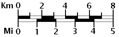
A large-scale map shows a small area in great detail (your town). A small-scale map shows a large area with little detail (all of Africa).
14 / 44
Measuring distance with a scale bar
The scale bar is the easiest way to measure distance. Here is the method.
Straight-line distance
- Lay the edge of a strip of paper between the two places on the map.
- Mark both places on the paper.
- Move the paper to the scale bar, putting one mark at zero.
- Read off how many kilometres the other mark reaches.
Worked example On a map with a scale bar where 2 cm = 50 km, you measure Kumasi to Sunyani as 4 cm. 4 cm is twice 2 cm, so the distance is twice 50 km = 100 km. (The real road is longer because it bends.)
Distance along a winding road Roads bend, so you cannot use a straight edge. Instead:
- Put the edge of the paper at the start.
- Follow the road a short way until it bends, mark the paper, then turn the paper to follow the next straight piece.
- Keep going, adding each short straight section.
- Measure the total against the scale bar.
A piece of thread laid along the road and then straightened works too.
15 / 44
Working with a ratio scale
Ratio scales need a little arithmetic. Follow the steps and they are not hard.
A scale of 1 : 100 000 means 1 unit on the map = 100 000 of the same units on the ground.
So 1 cm on the map = 100 000 cm on the ground. 100 000 cm = 1 000 m = 1 km.
So on a 1 : 100 000 map, 1 cm = 1 km. Easy to remember.
Other common scales
- 1 : 50 000 → 1 cm = 500 m (half a kilometre)
- 1 : 25 000 → 1 cm = 250 m
- 1 : 1 000 000 → 1 cm = 10 km
Worked example On a 1 : 50 000 map, the clinic is 6 cm from the school. Real distance? 1 cm = 500 m, so 6 cm = 6 × 500 = 3 000 m = 3 km.
Worked example 2 On a 1 : 1 000 000 map, Accra to Kumasi measures 20 cm. Real distance? 1 cm = 10 km, so 20 cm = 200 km.
Try this
- 1 : 25 000, distance 8 cm. Real distance?
- 1 : 100 000, distance 15 cm. Real distance?
- On a 1 : 50 000 map, how many cm would show a 7 km road?
16 / 44
Choosing the right scale
Different jobs need different scales. Before you pick a map, ask: how much area do I need, and how much detail?
Large scale (e.g. 1 : 10 000) shows a small area, big. You can see individual buildings, footpaths, the school compound, the market stalls. Good for: finding a house, planning a new drain, drawing your school.
Medium scale (e.g. 1 : 50 000) shows a district. You see towns, main roads, rivers, hills. Good for: planning a journey, locating a village, seeing which farms are near a river.
Small scale (e.g. 1 : 5 000 000) shows a whole country or continent, small. You see regions, cities, big rivers. Good for: comparing regions, learning where places are.
Worked example Ama is giving directions to her house in Madina for a delivery. Should she draw a large-scale or small-scale map? Large scale. The driver needs to see streets and landmarks, not the whole of Accra.
Kofi wants to show where Ghana's cocoa grows. Which scale? Small scale, a map of the whole country, with the cocoa areas shaded.
Try this Which scale would you choose for a map of (a) the route from your classroom to the toilets, (b) the sixteen regions, (c) your district's health centres?
17 / 44
Recap: scale
- Scale tells you how much smaller the map is than the real place.
- Three ways to show it: a scale bar, a ratio (1 : 50 000), or a statement (1 cm to 500 m).
- To measure with a scale bar: mark the distance on a strip of paper, then read it against the bar.
- For winding roads, follow the road in short straight steps, or use a thread.
- With a ratio: 1 : 100 000 means 1 cm = 1 km. 1 : 50 000 means 1 cm = 500 m. Multiply the map distance by what 1 cm stands for.
- Large scale = small area, lots of detail. Small scale = big area, little detail.
Quick check
- On a 1 : 50 000 map, a river is 10 cm long. Real length?
- A scale bar shows 3 cm = 30 km. Two towns are 7.5 cm apart. Distance?
- Which has the larger scale, a map of Kumasi or a map of West Africa?
- Why is the real road distance usually longer than the straight-line distance you measure?
18 / 44
Grids: dividing the map into squares
When someone says "the clinic is in the middle of the map, a bit to the left", that is not very helpful. A grid solves this. It divides the map into squares, and each square has an address.
A grid is a set of lines drawn across the map. Vertical lines run north to south. Horizontal lines run east to west. Where they cross, they make squares.
The simplest grids use letters along one side and numbers along the other, like a game board. A square is named by its letter and number: B3, D7.
Many street maps use this system. The index lists "Makola Market … C4", and you look across to column C and down to row 4.
Worked example On a school map with a letter-number grid, the football field is in square C2 and the library is in A5. Which is further north (towards the top), if the rows are numbered from the top? Row 2 is nearer the top than row 5, so the football field is further north.
Try this Draw a 6 × 6 grid on squared paper. Label columns A to F and rows 1 to 6. Draw five things from your school compound in different squares and write their grid addresses.
19 / 44
Four-figure grid references
Proper survey maps use numbers along both sides. The vertical lines are called eastings (the numbers get bigger as you go east). The horizontal lines are called northings (bigger as you go north).
A four-figure grid reference names one whole square. The rule is:
Along the corridor, then up the stairs.
- Find the vertical line on the left edge of the square. Read its number (the easting). That is the first two figures.
- Find the horizontal line on the bottom edge of the square. Read its number (the northing). That is the last two figures.
So a square whose bottom-left corner is at easting 23 and northing 45 has the grid reference 2345.
Worked example A church sits in the square whose left line is 17 and whose bottom line is 62. Grid reference: 1762.
Common mistake: reading the northing first. Always eastings (across) first, then northings (up). Corridor, then stairs.
Try this Draw a grid with eastings 10 to 15 and northings 20 to 25. Put a dot for a school in square 1223 and a dot for a market in 1421. Swap with a friend and check.
20 / 44
Six-figure grid references
A four-figure reference gives a square that might be a whole kilometre wide. For something small, like a borehole, we need to be more exact. A six-figure grid reference points to a spot inside the square.
Imagine each square divided into ten strips across and ten strips up. The extra figures tell you how many tenths across and up the point is.
Method
- Find the four-figure reference of the square as before: easting, then northing.
- Estimate how many tenths across the square the point is (0 to 9). Put this figure after the easting.
- Estimate how many tenths up the square the point is. Put this figure after the northing.
Worked example A borehole is in square 2345. It is about 7 tenths across and 3 tenths up.
- Easting: 23, then 7 → 237
- Northing: 45, then 3 → 453 Grid reference: 237453.
A six-figure reference pins a place to within 100 m on a 1 : 50 000 map. That is why rescue teams, surveyors and the army use them.
Try this In square 1762, a well is 2 tenths across and 8 tenths up. Six-figure reference? (Answer: 172628.)
21 / 44
Worked example: using grid references
A pupil has a map of a district with eastings 30 to 36 and northings 50 to 56. Here are some features and where they are.
- Health centre: square 3152
- Primary school: square 3454
- Market: in square 3251, 6 tenths across, 4 tenths up
- Bridge over the river: in square 3355, 1 tenth across, 9 tenths up
Question 1. Give the six-figure reference of the market. Easting 32 + 6 = 326. Northing 51 + 4 = 514. Answer: 326514.
Question 2. Give the six-figure reference of the bridge. Easting 33 + 1 = 331. Northing 55 + 9 = 559. Answer: 331559.
Question 3. Which is further north, the health centre or the school? Health centre northing 52, school northing 54. The school is further north.
Question 4. Which is further east? Health centre easting 31, school easting 34. The school is further east. So the school is north-east of the health centre.
Try this Give a four-figure reference for a point at 345528, and say whether it is north or south of the bridge.
22 / 44
Worked example: directions on a street map
Kofi is new in Cape Coast. He has a street map and must get from the lorry park to the hospital. Here is how he uses the map.
Step 1: Find both places. He uses the index: "Lorry park … D3" and "Regional Hospital … B5". He finds both squares.
Step 2: Work out the general direction. From D3 to B5 means moving left (west) two columns and down (south) two rows. So the hospital is roughly south-west of the lorry park.
Step 3: Find a route. He looks for roads (line symbols) joining the two squares. A main road runs south from D3 to D5, then another runs west from D5 to B5.
Step 4: Measure. With a strip of paper along the two straight parts, he gets 6 cm. The scale bar shows 2 cm = 500 m, so the walk is about 1 500 m, or 1.5 km, about twenty minutes.
Step 5: Note landmarks. The key shows a church symbol at the corner where he must turn west. He will know the turn when he sees the church.
Step 6: Line up the map. Outside, he turns the map so its north arrow points north (the sea is south, so he puts the sea side towards the sea). Now "left on the map" is left in real life.
Try this Write similar steps for a visitor going from your school to the nearest market.
23 / 44
Ghana and the Prime Meridian
Besides grids, the whole Earth has its own system of lines: latitude and longitude.
Lines of latitude run east to west around the Earth, parallel to the Equator (0°). They measure how far north or south a place is. Ghana lies between about 5°N (the coast) and 11°N (the northern border). It is entirely in the northern hemisphere, close to the Equator, which is why it is hot all year.
Lines of longitude run from the North Pole to the South Pole. They measure how far east or west a place is from the Prime Meridian (0°), the line that passes through Greenwich in London.
Here is something special: the Prime Meridian passes through Ghana. It crosses the coast at Tema, just east of Accra, and runs north through the Volta Region and up to the Burkina Faso border. Ghana is one of only a handful of countries on the 0° line. This is also why Ghana's time is Greenwich Mean Time (GMT).
So most of Ghana is slightly west of 0° (Kumasi is about 1.6°W, Wa about 2.5°W), and a thin strip in the east is slightly east of 0° (Ho is about 0.5°E).
Try this On a map of Ghana with latitude and longitude lines, find the 0° line. Which towns lie almost on it?
24 / 44
Recap: grids and references
- A grid divides a map into squares so each place has an address.
- Simple maps use letters and numbers (C4). Survey maps use numbers on both edges.
- Eastings are the vertical lines; the numbers grow as you go east. Northings are the horizontal lines; the numbers grow as you go north.
- Four-figure reference = one square. Read the easting on the left of the square, then the northing on the bottom. Along the corridor, then up the stairs.
- Six-figure reference = a point in the square. Add tenths across after the easting and tenths up after the northing.
- Example: square 2345, 7 tenths across, 3 tenths up → 237453.
Quick check
- Which comes first in a grid reference, easting or northing?
- What is the four-figure reference of the square whose bottom-left corner is at easting 08, northing 91?
- In that square, a point 5 tenths across and 5 tenths up. Six-figure reference?
- Why would a fire service want a six-figure reference instead of a four-figure one?
25 / 44
The map of Ghana: shape and neighbours
Now let us use all these tools on the map that matters most to you.
Ghana is in West Africa, on the coast of the Gulf of Guinea, part of the Atlantic Ocean. The country is roughly a rectangle, about 670 km from north to south and about 560 km from east to west at its widest.
Neighbours
- North: Burkina Faso
- East: Togo
- West: Côte d'Ivoire
- South: the Gulf of Guinea (sea)
Key places to find
- Accra, the capital, on the coast in the south-east.
- Kumasi, the second city, in the centre.
- Tamale, the largest city in the north.
- Takoradi and Tema, the two big ports.
- Lake Volta, one of the largest man-made lakes in the world, running down the east of the country.
- Mount Afadja, the highest point, near the Togo border.
Try this On a blank outline of Ghana, mark the four neighbours and these six places from memory. Then check with an atlas.
26 / 44
The map of Ghana: sixteen regions
Since 2019 Ghana has had sixteen regions. Each has a capital town where the Regional Minister works.

Along the coast (south): Western (Sekondi-Takoradi), Central (Cape Coast), Greater Accra (Accra), Volta (Ho).
Middle belt: Western North (Sefwi Wiawso), Ashanti (Kumasi), Eastern (Koforidua), Ahafo (Goaso), Bono (Sunyani), Bono East (Techiman), Oti (Dambai).
North: Savannah (Damongo), Northern (Tamale), North East (Nalerigu), Upper East (Bolgatanga), Upper West (Wa).
Reading the map with directions
- Volta Region is on the eastern border with Togo.
- Upper West is in the north-west corner.
- Ashanti is in the centre.
- Greater Accra is the smallest region by area but has the most people.
Try this Which region do you live in? Name all the regions that share a border with it, and give the direction of each one from your region.
27 / 44
The map of Ghana: relief
A relief map (or physical map) shows the shape of the land: where it is high, where it is low, where rivers run.

Look at the key in the corner. Colours stand for height above sea level. Low land is green; higher land is pale yellow and brown. Blue is water.
What the map shows:
- Most of Ghana is low (under 300 m). The land rises gently from the coast.
- The highest land is the Akwapim-Togo Ranges along the eastern border, where Mount Afadja (885 m) stands.
- The Kwahu Plateau forms a curved ridge across the middle of the country.
- Lake Volta fills a huge area in the east. The Black Volta and White Volta rivers flow into it from the north.
- The coast is mostly flat, with lagoons near Keta and Accra.
Try this Use the compass directions to describe where the highest land is. Use the key to estimate the height of the land around Tamale.
28 / 44
Travelling across Ghana with a map
Let us plan a journey using every map skill.
Journey: Kofi travels from Accra to Tamale to visit his grandmother.
Direction. Put the compass rose on Accra. Tamale is almost straight north, slightly west.
Distance. On a map with scale 1 : 5 000 000 (1 cm = 50 km), Accra to Tamale measures about 12.5 cm in a straight line. 12.5 × 50 = about 625 km. By road it is further, roughly 650 km, because the road passes through Kumasi.
Route. Using the key, Kofi finds the main road (a thick line) from Accra north through Nsawam and Nkawkaw to Kumasi, then on through Techiman and Kintampo to Tamale.
Regions passed through. Greater Accra → Eastern → Ashanti → Bono East → Savannah → Northern.
Landmarks. The road crosses the Kwahu Plateau near Nkawkaw (steep, winding) and passes Kintampo, where the waterfalls are.
Time. A bus at about 60 km/h would take 650 ÷ 60 ≈ 11 hours, plus stops.
Try this Plan a journey from your town to Cape Coast in the same way: direction, distance, route, regions, landmarks.
29 / 44
Recap: the map of Ghana
- Ghana is in West Africa on the Gulf of Guinea. Neighbours: Burkina Faso (N), Togo (E), Côte d'Ivoire (W), the sea (S).
- Since 2019 there are sixteen regions, each with a capital. Greater Accra is the smallest in area but has the most people.
- A relief map uses colours for height. Most of Ghana is low; the highest land is the Akwapim-Togo Ranges in the east, with Mount Afadja (885 m).
- Lake Volta is a huge man-made lake in the east, fed by the Black and White Volta rivers.
- Major cities: Accra (capital), Kumasi (centre), Tamale (north), Takoradi and Tema (ports).
- To plan a journey: find the direction, measure the distance with the scale, follow the road with the key, note the regions and landmarks.
Quick check
- Which region is in the north-west corner?
- Name the two rivers that feed Lake Volta.
- Which direction is Ho from Kumasi?
- If 1 cm = 50 km and Kumasi to Tamale is 7.5 cm, what is the distance?
30 / 44
Your district
Ghana's regions are divided into districts, more than 260 of them. Each district has a District Assembly and a District Chief Executive. Some larger ones are called Municipal or Metropolitan assemblies. Your school, your clinic and your market are all run with help from your district.
A district map is a large-scale map. It shows:
- the district boundary (usually a thick dashed line)
- the district capital (where the assembly meets)
- towns and villages
- roads, with the main ones marked clearly
- rivers and streams
- schools, health centres, markets
- sometimes farmland, forest reserves and mining areas

Where to find your district map: the District Assembly office, the District Education Office, the Ghana Statistical Service website, and free online maps such as OpenStreetMap, which volunteers in Ghana are improving every day.
Try this Find out the name of your district, its capital, and the name of your District Chief Executive.
31 / 44
Worked example: reading a district map
Abena has a map of her district. Here is how she reads it, step by step.
1. Title. "Ajumako-Enyan-Essiam District, Central Region". So she knows the district and the region.
2. Key. She finds: thick red = trunk road; thin red = feeder road; black cross = health facility; blue = rivers; dashed line = district boundary.
3. Compass. North is at the top.
4. Scale. 1 : 150 000, so 1 cm = 1.5 km.
5. Finding her town. She finds Ajumako, the district capital, near the centre.
6. Questions she can now answer:
- Which direction is Essiam from Ajumako? She lays the compass rose on Ajumako. Essiam is to the south-west.
- How far is the nearest hospital? She finds the cross symbol, measures 5 cm, and calculates 5 × 1.5 = 7.5 km.
- Which towns are on the trunk road? She follows the thick red line and lists them.
- Which river forms part of the boundary? She follows the dashed line until it runs along a blue line.
Try this Do the same six steps with a map of your own district, and write down three facts you did not know before.
32 / 44
Drawing a map of your school
Making a map is the best way to understand one. Follow these steps to map your school compound.
1. Walk and observe. Walk around the compound. Note the buildings, the field, the gate, trees, water points, paths.
2. Pace it out. Count your steps along the longest side of the compound and the shortest side. Measure one of your steps with a ruler so you can convert.
3. Choose a scale. If the compound is 100 m long and your paper is 20 cm, use 1 cm = 5 m (1 : 500).
4. Draw the outline of the compound to scale.
5. Add the features in the right places and roughly the right sizes. Use simple symbols: a rectangle for a classroom block, a circle for a tree, a small triangle for a tap.
6. Add the five tools: a title ("Map of … JHS"), a key explaining your symbols, a scale statement or bar, a compass arrow (find north with the sunrise or a phone), and a grid of letters and numbers.
7. Test it. Give it to a friend and ask them to find the headteacher's office using only your map.
33 / 44
Maps on phones
Most maps people use today are on a phone. They follow the same rules as paper maps, but with some differences.
The same:
- There is a key, though it is often hidden in a menu or the symbols are explained when you tap them.
- There is a scale bar, usually in the corner, which changes when you zoom.
- North is at the top, unless you turn on "rotate with direction".
- Rivers are blue, parks are green, main roads are thick.
Different:
- You zoom instead of choosing a scale. Zooming in makes the scale larger; zooming out makes it smaller.
- A blue dot shows where you are, using satellite signals (GPS).
- You can search instead of using a grid reference.
- The map can give directions and estimate travel time.
Be careful. Phone maps can be wrong or out of date, especially for footpaths and small villages. Rural roads may be missing. And a phone battery can die. Knowing how to read a paper map is still a skill worth having.
Try this If you can borrow a phone, open a map, find your school, and zoom in and out while watching the scale bar change.
34 / 44
Recap: your district and making maps
- Ghana's regions are divided into districts (more than 260), each run by a District Assembly.
- A district map is large-scale: it shows towns, roads, rivers, boundaries, schools and clinics.
- To read any map: title → key → compass → scale → find your place → ask questions.
- To draw a map: observe, pace it out, choose a scale, draw the outline, add features with symbols, then add the five tools.
- Phone maps use the same ideas (key, scale, north, symbols) but let you zoom, search and see where you are. They can still be wrong, so paper map skills matter.
Quick check
- Where could you find a map of your district?
- On a school map with 1 cm = 5 m, a classroom block is 6 cm long. How long is it really?
- What happens to the scale bar on a phone map when you zoom in?
- Name one thing a paper map can do that a phone map with a dead battery cannot.
35 / 44
Common mistakes
Reading the map before the key. You assume blue means river, but on this map it means a district boundary. Always check the key first.
Northings before eastings. Grid reference 4523 is a different square from 2345. Corridor first, then stairs.
Adding instead of multiplying scale. On 1 : 50 000, 4 cm is 4 × 500 m = 2 km, not "4 + 500".
Forgetting that roads bend. A straight-line measurement is always shorter than the road.
Mixing up large and small scale. Large scale = small area, big detail (your town). Small scale = big area, little detail (Africa). The words feel backwards, so learn them carefully.
Assuming north is always at the top. It usually is, but check the compass arrow. Some maps are turned to fit the page.
East and west swapped. Facing north, east is on your right. Think of the sun rising on your right hand as you face north.
Using an old map. A map from 2015 shows ten regions. Check the date in the title.
Trusting one map for everything. A roads map will not show rainfall. A rainfall map will not show schools. Choose the map for the question.
36 / 44
Map puzzles
Try these. Each one uses a skill from this book. Draw a sketch if it helps.
1. Directions. Ama walks north for 2 km, then east for 2 km, then south for 2 km. In which direction is she from her starting point, and how far?
2. Opposite. A bus travels from Kumasi towards Takoradi, which is south-west. On the way back, in which direction is it travelling?
3. Scale. On a 1 : 50 000 map, a footpath measures 3 cm. A pupil walks at 4 km per hour. How long will the walk take?
4. Scale again. Two maps show the same village. On map A the village is 1 cm wide; on map B it is 5 cm wide. Which map has the larger scale? Which would show the individual houses?
5. Grid. The school is at 1823 and the clinic at 2125. Is the clinic north-east, north-west, south-east or south-west of the school?
6. Six figures. The well is at 184236. Which square is it in? Is it nearer the left or the right side of that square?
7. Key. A map shows a thick blue line and a thin blue line. Suggest what each might be.
8. Regions. Name a region that borders both Togo and Burkina Faso.
Check your answers with a partner. Where you disagree, draw it out together.
37 / 44
Why map skills matter
Reading a map is not just for exams. Many jobs in Ghana depend on it every day.
Surveyors measure land and draw the maps that settle who owns which plot. Land disputes are common, and a good map prevents them.
Town planners at the district assembly use maps to decide where new roads, schools and drains should go.
Drivers of long-distance buses, trucks and trotros need to know routes, distances and alternatives when a road is closed.
Health workers map where cases of cholera or malaria appear, to find the source and stop the spread.
NADMO (the National Disaster Management Organisation) uses maps to plan for floods: which areas are low, which roads will be cut off, where people can shelter.
Farmers and agricultural officers map soils, rainfall and crops to advise what to plant where.
Miners, foresters, fishermen, pilots, soldiers, police and delivery riders all read maps.
And every citizen benefits: knowing where your district boundary runs, where the nearest clinic is, and how to get to a new place without getting lost.
Try this Choose one of these jobs. Write three questions that person might ask a map on a normal working day.
38 / 44
Key words
Map – a drawing of a place from above, made smaller. Title – tells you what and when the map shows. Key / legend – explains the colours, lines and symbols. Symbol – a small picture or shape standing for a real thing. Scale – how much smaller the map is than real life. Scale bar – a drawn ruler marked in kilometres. Ratio scale – e.g. 1 : 50 000, 1 cm on the map = 50 000 cm on the ground. Large scale / small scale – small area with detail / large area with little detail. Compass rose – the drawing that shows north and the other directions. Cardinal points – N, E, S, W. Intercardinal (ordinal) points – NE, SE, SW, NW. Grid – lines dividing the map into squares. Eastings – vertical grid lines, numbered increasing eastwards. Northings – horizontal grid lines, numbered increasing northwards. Four-figure grid reference – names a square. Six-figure grid reference – names a point inside a square. Relief map – shows the height and shape of the land. Region / district – Ghana's levels of local government. Sixteen regions; over 260 districts.
39 / 44
Self-test
Answers on the next page.
- Name the five parts of a map.
- Which part of the map should you read first?
- What are the four cardinal points, in clockwise order from the top?
- Which direction is between south and west?
- If you face east, which direction is behind you?
- Which country is north of Ghana?
- On a 1 : 100 000 map, 1 cm equals how many km?
- On a 1 : 50 000 map, a road measures 9 cm. Real length?
- Which has the larger scale: a map of your school or a map of Ghana?
- What are the vertical grid lines called?
- Give the four-figure reference of the square with bottom-left corner at easting 41, northing 27.
- In that square, a point 3 tenths across, 8 tenths up. Six-figure reference?
- How many regions does Ghana have today?
- Name the capital of the Northern Region.
- Which region is in the north-west corner of Ghana?
- What is Ghana's highest mountain and roughly how high is it?
- Which large lake lies in the east of Ghana?
- What colour usually shows water on a map?
- Why is a straight-line distance shorter than the road distance?
- Name one way a phone map differs from a paper map.
40 / 44
Self-test answers
- Title, key (legend), scale, compass, grid.
- The title.
- North, east, south, west.
- South-west.
- West.
- Burkina Faso.
- 1 km.
- 9 × 500 m = 4 500 m = 4.5 km.
- The map of your school.
- Eastings.
- Sixteen.
- Tamale.
- Upper West.
- Mount Afadja (Afadjato), about 885 m.
- Lake Volta.
- Blue.
- Because roads bend around hills, rivers and towns.
- Any one of: you zoom instead of choosing a scale; a dot shows where you are; you can search; it gives directions; it can be out of date or run out of battery.
Score: 18–20 excellent · 13–17 good, revisit the pages you missed · below 13, reread the recap pages and practise grid references with a friend, then try again.
41 / 44
Learn more
- Ordnance Survey: Map reading guide (PDF) — a free booklet on symbols, scale, compass and grid references
- OpenStreetMap — a free map of the world that anyone can improve; zoom in to find your own town
- National Geographic Education: Map — an illustrated explanation of what maps are and the kinds of maps there are
- Wikipedia: Regions of Ghana — the sixteen regions, their capitals and when they were created
- Ghana Statistical Service — official maps and population figures for regions and districts
42 / 44
Watch more
43 / 44
Think about it
- Why do most maps put north at the top? Is there any reason a map could not put south at the top?
- Which three places in your district would you most want to see on a map, and why?
- If you were drawing a map for a visitor who cannot read, how would you design the key?
- Ghana went from ten regions to sixteen in 2019. What problems does this cause for people using old maps, and who needs to be told?
- Phone maps know where you are. Is that always a good thing?
44 / 44
This book is for reading on SchoolSpec and cannot be printed.